Friday, August 21, 2009

Lehigh River Watershed


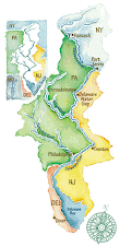
This is an image of the Lehigh River watershed in eastern Pennsylvania. The river runs between Lehigh County on the west and Northampton County on the east. The name "Lehigh" is an aanglicized version of a Lenni Lenape name. Many of the creeks also carry names given by this tribe who are part of the Algonquins.

The river flows south from Carbon County. I'm not sure where its source is. There used to be canals running alongside the river - some are still there - that were used to transport anthracite (hard coal) from those northern regions to the Delaware River, and down to Philadelphia. Mules used to pull the canal boats. You can take a canal boat ride, sponsored by the National Canal Museum in Easton. When I moved to Pennsylvania from Texas many years ago, one of the first outings I took was a nice float on the canal boat "Josiah White," pulled by hard-working mules.

Click on this link for information about the canals and boat rides:
http://www.canals.org/

Monday, August 17, 2009

Book Review: Peoples of the River Valleys: The Odyssey of the Delaware Indians


The Spring 2009 issue of the journal Pennsylvania History includes a book review of Peoples of the River Valleys: The Odyssey of the Delaware Indians by Amy C. Schutt. The book was published by Philadelphia: University of Pennsylvania Press in 2007.

Written by Thomas J. Lappas of Nazareth College of Rochester, the review is generally complimentary. Lappas mentions that all scholars of colonial-era Native American history must depend on imperfect sources and make conjectural assertions. He concludes that Schutt "usually remains on solid ground in her interpretations" but he does mention some questionable areas.

According to Lappas, Schutt explains how and why the eastern dialectical groups - the Unami, Unalachtigo and Munsee Delawares were forced to move westward. They migrated throuigh Pennsylvania and ultimately to Ohio, forming and reforming their communities.

Lappas says that the book's narrative is held together by the "argument that alliance formation among Delawares and their neighboring groups was a salient characteristic of life before, during and after their 'odyssey'."

Schutt provides "excellent" maps that include details of villages, streams and rivers, and also movement of the Delawares and relationships among their allies and enemies, per Lappas.

Friday, August 14, 2009

Delaware River Basin

The material is copied from the following New Jersey State website on the Delaware River Basin.

http://www.state.nj.us/drbc/map2.htm

The green drawing of the entire basin (at top of right side of this blog) is also copied from this site.

The mainstem Delaware River, the longest un-dammed river east of the Mississippi, extends 330 miles from the confluence of its East and West branches near Hancock, New York, to the mouth of the Delaware Bay.

Approximately five percent of the nation's population relies on the basin's waters for drinking and industrial use, and the bay is only a gas tank away for about 23 percent of the people living in the United States. Yet, the watershed drains only 0.4 percent of the continental U.S. land area.

In all, the basin comprises 13,539 square miles, including portions of Delaware, New Jersey, New York, and Pennsylvania.